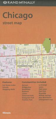
Rand McNally
product information
Condition: New,
UPC: 9780528007842,
Publication Date: Mon, October 1, 2018,
Type: Calendar/Blank Book ,
description
0Rand McNally's folded map for Chicago is a must-have for anyone traveling in and around this part of Illinois, offering unbeatable accuracy and reliability at a great price. Our trusted cartography shows all Interstate, U.S., state, and county highways, along with clearly indicated parks, points of interest, airports, county boundaries, and streets. The easy-to-use legend and detailed index make for quick and easy location of destinations. You'll see why Rand McNally folded maps have been the trusted standard for years.
Regularly updated
Full-color maps
Clearly labeled Interstate, U.S., state, and county highways
Indications of parks, points of interest, airports, county boundaries, schools, shopping malls, downtown & vicinity maps
Easy-to-use legend
Detailed & full street index
Convenient folded size
Coverage Area
Communities Included: Berwyn, Bridgeview, Brookfield, Burbank, Cicero, Elmwood Park, Evergreen Park, Franklin Park, La Grange, Lyons, Oak Lawn, Oak Park, Riverside, Willow Springs plus downtown enlargement map
Product Details
Measures 9.5' x 4' and folds out to 40' x 28'.
1 inch represents approximately 0.5 miles, or 1:31,680
member goods
No member items were found under this heading.
notems store


listens & views


Return Policy
All sales are final
Shipping
No special shipping considerations available.
Shipping fees determined at checkout.