National Geographic Maps - Trails Illust
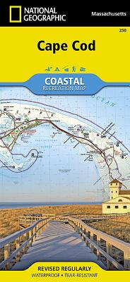
Let National Geographic's Cape Cod Coastal Recreation map lead you both on land and on water, along some of America's most picturesque shorelines. Created in partnership with the National Park Service and others, the map provides unparalleled detail of the area. The beach guide lists the location and facilities available at more than 100 private and public beaches, sorted by town. Likewise, the marina guide lists the services, supplies and facilities at the marinas, along with maximum vessel size and water depth. In addition to beaches and marinas, other recreation features displayed on the map include: visitor centers, campgrounds, boat launches, interpretive trails, lighthouses, wildlife viewing areas, diving areas and golf courses. Hikers and bikers will find trails clearly marked, color-coded according their designated use, including the Cape Cod Rail Trail. A trail guide describes some of the more popular trails along with their distances and designated use.
For boaters additional essential information is displayed on the map, such as landings, soundings, tidal flats, navigation buoys and beacons. Moreover, a guide to reading buoys and other navigation safety tips are listed. QR codes will allow you to conveniently connect to the U.S. Coast Guard Navigation Center as well as to check current weather conditions. The map also serves as a detailed road map, not only of the Mid-Cape Highway and scenic Old King's Highway but for local roads in all sections of the Cape as well. The map covers the Upper Cape, from Sandwich and Mashpee; through the Mid-Cape, including Nantucket Sound; then to the Lower and Outer Cape, including the Cape Cod National Seashore, Monomoy National Wildlife Refuge, Wellfleet and Provincetown Harbors, Nauset Beach and Nickerson State Park.
Every Trails Illustrated map is printed on "Backcountry Tough" waterproof, tear-resistant paper. A full UTM grid is printed on the map to aid with GPS navigation.
Other features found on this map include: Cape Cod, Dennis, Harwich, Mashpee, Nauset Beach, Race Point, Sandwich, Sandy Neck, Wellfleet Harbor, Yarmouth.
- Map Scale = 1:63,360
- Sheet Size = 25.5" x 37.75"
- Folded Size = 4.25" x 9.25"
member goods
notems store


listens & views

MONTSERRAT CABALLE SINGS PUCCINI ARIAS
by PUCCINI / CABALLE / MACKERRAS / LONDON SYM ORCH
COMPACT DISC$17.25