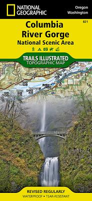
National Geographic Maps - Trails Illust
- Waterproof - Tear-Resistant - Topographic Map
The magnificent Multnomah Falls is just one of many natural, cultural, and recreational attractions in the Columbia River Gorge Scenic Area. The 80-mile-long gorge contains diverse ecosystems ranging from the lush Oneonta Gorge Rain Forest to the arid Celilo Grasslands. Expertly researched and created in partnership with local land management agencies, National Geographic's Trails Illustrated map of Columbia River Gorge provides an unparalleled tool for exploring this breathtaking region. Some of the key areas of interest featured on the map include the White Salmon, Klickitat, Sandy, and Lower Deschutes rivers; Yacolt Burn State Forest; Maryhill, Columbia Hills, and Rooster Rock state parks; Mark O. Hatfield Wilderness; and portions of Mount Hood and Gifford-Pinchot national forests.
With miles of clearly marked trails including the Pacific Crest National Trail and the Oregon National Historic Trail, and such scenic roadways as the Historic Columbia River Highway and Yakima Scenic Byway, this map will prove invaluable whether you're taking in the scenery on foot or by car. A helpful list of waterfalls makes it easy to take in these natural wonders in your travels. Many recreation features are noted as well, including campgrounds, trailheads, interpretive trails, boat launches, and areas for fishing, windsurfing, and swimming. The map base includes contour lines and elevations for summits.
Every Trails Illustrated map is printed on Backcountry Tough waterproof, tear-resistant paper. A full UTM grid is printed on the map to aid with GPS navigation.
Other features found on this map include: Bonneville Dam, Bull Run Reservoir Number One, Camas, Columbia Hills, Deschutes River, Gifford Pinchot National Forest, Gresham, Hood River, Klickitat River, Lake Celilo, Mark O. Hatfield Wilderness, Mount Defiance, Mt. Hood National Forest, Multnomah Falls, Shellrock Mountain, The Dalles, Troutdale, Washougal, White Salmon River.
- Map Scale = 1:75,000
- Sheet Size = 37.75 x 25.5
- Folded Size = 4.25 x 9.25
member goods
notems store

Washington Road & Recreation Atlas ...
by Benchmark Maps and. Atlases
Calendar/Blank Book /Other$18.71


listens & views


GAMBA SONATAS BWV1027-29 CHORALE - ...
by BACH,J.S. / SCARLATTI,D. / EGARR,RICHARD
COMPACT DISC$18.25