National Geographic Maps
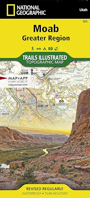
A premier destination for mountain biking, hiking, whitewater rafting, four-wheeling, and more, Moab offers adventure and recreation in one of the most iconic landscapes in the United States. National Geographic's Trails Illustrated maps of Moab were created in partnership with local land management agencies and adventure experts to provide unmatched detail of the area, with useful up-to-date information to guide and enrich your visit.
The Moab Greater Region map shows all of the major trail systems, public lands, and recreation sites in and around Moab. Particularly useful for motorized off-road vehicle use, it features 29 highlighted 4x4 trails, with trail segments labeled with mileage between intersections. The region's 10 major mountain bike trail areas are clearly mapped and labeled including Magnificent Seven, Rodeo, Navajo Rocks, Klondike Bluffs, Bar M (Moab Brands), Amasa Back, Klonzo, Sand Flats, Sovereign, and Whole Enchilada. The map includes all of Arches National Park and Dead Horse Point State Park, along with sections of Canyonlands National Park, Manti-La Sal National Forest, Bears Ears National Monument, Labyrinth Canyon Wilderness, and dozens of BLM Special Recreation Management Areas.
Trails are symbolized by use types, with trail difficulty listed for mountain bike and 4x4 trails. Trail system comparison charts are included for 4x4 and mountain bike areas to help choose areas to explore given time, skill, and equipment constraints. Colorado River access points and mileages are mapped and labeled for river recreation. Visitor centers, campgrounds, interpretive trails, and scenic overlooks are prominently mapped and labeled with their amenities. OHV, biker, and desert safety tips, laws, and etiquette are also provided.
Every Trails Illustrated map is printed on "Backcountry Tough" waterproof, tear-resistant paper. A full UTM grid is printed on the map to aid with GPS navigation.
Other features found on this map include: Colorado River, Green River, Dolores River, Hatch Point, La Sal Mountains, Mineral Point, Mount Peale, Salt Valley.
- Map Scale = 1:90,000
- Sheet Size = 37.75" x 25.5"
- Folded Size = 4.25" x 9.25"
member goods
notems store
Mount Tamalpais, Point Reyes
by National Geographic Maps - Trails Illust
Calendar/Blank Book /Folded$11.21
listens & views

SCHUMANN: SYM NOS 1 & ...
by SCHUMANN / GENDRON / LIPATTI / OSR / ANSERMET
COMPACT DISCout of stock
$15.99