National Geographic Maps
product information
Condition: New,
UPC: 9781597753609,
Publication Date: Fri, December 1, 2017,
Type: Calendar/Blank Book ,
description
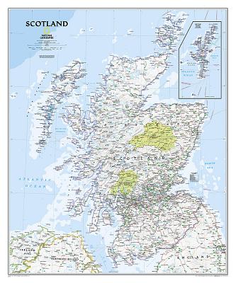
Scotland is one of the largest and most detailed maps of the country. The signature Classic style design uses a bright, easy-to-read color palette featuring blue oceans and stunning shaded relief that has been featured on National Geographic wall maps for over 75 years. This map includes hundreds of named places including primary and secondary towns, counties, political boundaries, infrastructure, and selected historical sites. Scotland is shown in its entirety including the Highlands, Southern Uplands, Isle of Skye, Outer Hebrides, Inner Hebrides, Orkney Islands and the Shetland Islands (shown in an inset map). The nine political council areas of Scotland are also clearly identified.
The map is packaged in a two inch diameter tube with a label showing a thumbnail of the map with dimensions and other pertinent information.
- Map Scale = 1:650,000
- Sheet Size = 30" x 36"
member goods
No member items were found under this heading.
notems store


listens & views


Return Policy
All sales are final
Shipping
No special shipping considerations available.
Shipping fees determined at checkout.