National Geographic Maps
- Waterproof - Tear-Resistant - Topographic Map
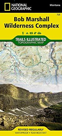
Explore the wonders of the Bob Marshall Wilderness Complex with National Geographic's Bob Marshall Wilderness Trails Illustrated Map. This area includes four national forests and the Great Bear, Bob Marshall, and Scapegoat Wilderness Areas. Encompassing the highest concentration of grizzlies in the continental U.S., this region extends from Seeley Lake in the South to the northern tip of Hungry Horse Reservoir and spreads East to Glacier National Park, with all of Sun Valley on the West. This expertly researched and highly detailed map includes the Flathead and Swan Mountain Ranges, the Chinese Wall along the Continental Divide, the renowned Jewel Basin, and the Sun River Game Preserve. Also depicted are the South Fork and the southern section of the Middle Fork of the Flathead Wild River. This map will guide you through stunning wilderness with miles of mapped trails and clearly marked trailheads.
Every Trails Illustrated map is printed on Backcountry Tough waterproof, tear-resistant paper. A full UTM grid is printed on the map to aid with GPS navigation.
A portion of the proceeds from the purchase of a National Geographic map help support the Society's vital exploration, conservation, scientific research, and education programs.
Other features found on this map include: Augusta, Choteau Mountain, Condon, East Glacier Park, Essex, Flathead Alps, Flathead National Forest, Flathead Range, Four Horns Lake, Gibson Reservoir, Gilman, Holland Peak, Lewis and Clark Range, Marmot Mountain, McDonald Peak, Mission Range, Mount Baptiste, Mount Saint Nicholas, Ovando Mountain, Pentagon Mountain, Pinnacle, Pishkun National Wildlife Refuge, Placid Lake, Red Mountain, Sawtooth Range, Scarface Peak, Seeley Lake, Silvertip Mountain, Swan Lake, Swan Range, Willow Creek National Wildlife Refuge.
- Map Scale = 1:126,720
- Sheet Size = 25.5 x 37.75
- Folded Size = 4.25 x 9.25
member goods
notems store

listens & views