Harrison, Tom
product information
Condition: New,
UPC: 9781877689345,
Publication Date: Fri, August 1, 2014,
Type: Calendar/Blank Book ,
description
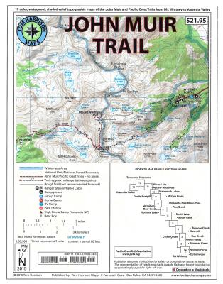
e famous Sierra High Route that will take hikers from Mount Whitney to Yosemite, CA. Well marked trails over USGS topo maps that were beautifully enhanced with shaded relief to better distinguish details. Scale 1:630360. 1 inch on map equals 1 mile. Whitney Portal, Symmes Creek, Onion Valley, Oak Creek, Taboose Creek, North and South Lakes, Vermilion, Bear Creek, Florence Lake, Pine Creek, Mono Pass, McGee Creek, Devils Postpile, Mammoth Lakes, Agnew Meadows, Silver Lake, Tuolomne Meadows, and finally the Yosemite Valley. GPS Compatible! - Complete UTM Grid.
member goods
No member items were found under this heading.
notems store


listens & views


Return Policy
All sales are final
Shipping
No special shipping considerations available.
Shipping fees determined at checkout.